-40%
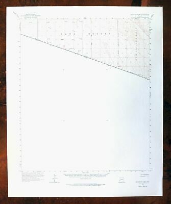
South Of Yuma San Luis Arizona Vintage Original USGS Topo Map 1964 Topographic
$ 15.31
- Description
- Size Guide
Description
SOUTH OF YUMA ARIZONA VINTAGE ORIGINAL USGS TOPO MAP 1964 TOPOGRAPHICALVintage Cartographics
Arizona Maps
∙
Antique Prints
∙
Bargain Bin
∙
Browse Nearby Sheets
1964
South Of Yuma
Arizona
USGS TOPOGRAPHIC MAP
1966 print in excellent condition
For sale is the 1964 edition of the South Of Yuma 15-minute map. This map would be ideal for framing or display, historical reference or research, genealogy studies, adding to your collection, treasure hunting, a nice conversation piece, a gift for a history or map enthusiast, or for anyone interested in this area. Maps of this vintage are printed on durable stock and are well-suited for outdoor activities and recreation of all kinds.
This sheet includes the only survey produced by the United States Geological Survey for the South Of Yuma 15-minute quadrangle. The map sheet is an original 1966 USGS print in excellent condition.
The South Of Yuma 15-minute map shows all roads, paths, towns, railroads, rivers, creeks, elevation contour lines, public land survey lines, county, state, and other administrative boundaries as they existed at the time of the survey in 1937 through 1964. All known structures (houses, businesses, churches, schools, barns, cabins, etc) are also shown.
Maps from the 15-minute series for the continental United States are no longer produced or printed by the USGS and original prints are becoming increasingly difficult to find. They are a valuable historical record for an area, as they contain many placenames and features that have been dropped from more recent maps.
MAP DETAILS
Title
South of Yuma
State
Arizona
Series
15-minute
Surveyed
1937 through 1964 Aerial and Field Survey
Edition
1964
Printed
1966, thick paper stock
Woodland Tint
No
Scale
1:62500
Contour Interval
5 Foot
Sheet Dimensions
17 7/8 x 22 inches
Map Dimensions
14 3/4 x 17 1/2 inches
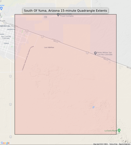
Coverage Area
15 x 17 miles
Notes
Mexico side of border not surveyed, from the vintage map collection of Art Christiansen, Tempe, Arizona
SHEET CONDITION
Overall Condition
EXCELLENT
Sheet Notes
very lightly handled, never folded, smooth and flat
Map Area
flawless map area
Collar Area
no wear, no markings, no blemishes
MAP COVERAGE
Quadrangle extent overlaid on current basemap.
Browse Nearby
Sheets
PLACENAMES
Depending on map series and survey date, all of the features listed below may not be shown on this map. This list contains features that currently exist or historically existed within the area covered by this map. The list can be used as a reference to determine if this map covers your area of interest. Placenames are listed alphabetically next to each feature type.
Cities and Towns
(current)
San Luis and Yuma
Counties Covered
Yuma
Federal Land Units
Barry M. Goldwater Air Force Range
SHIPPING AND RETURNS
This map sheet will be carefully rolled in a sturdy tube and shipped via the US Postal Service. Shipping and handling costs are included in the purchase price.
If you find that the sheet you receive is not as described in the listing, you may ship it back to us for a refund of the purchase price.
15~12044 15~12045 15~12046 15~12047 15~12048 15~12200 15~12201 15~12202 15~12203 15~12204 15~12205 15~12206 15~12352 15~12353 15~12354 15~12355 15~12495 30~3103 30~3104 60~142 60~159 60~160 60~981 75~46847 75~46848 75~47126 75~47127 75~47138 75~47139 75~47140 75~47141 75~47142 75~47418 75~47419 75~47420 75~47421 75~47422 75~47695 75~47696


