-40%
GENEALOGY ILLINOIS PLAT MAP MASON COUNTY pre-1940 ORIGINAL
$ 10.13
- Description
- Size Guide
Description
GENEALOGY PLAT MAP ILLINOIS,ORIGINAL
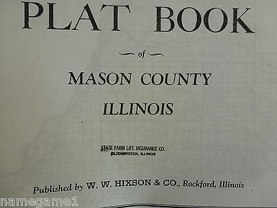
Plat book of Mason County, Illinois by W. W. Hixson & Co., Rockford, Ill.
22 pages, stapled.
Mason County was created from Tazewell and Menard County in 1841 and is bounded by Fulton, Tazewell, Logan and Menard. County seat is Havana.
There is no cover page. Includes a map of the complete county and a map for each township within the county. Each map of the townships and ranges includes rivers, roads, railroads, some public buildings, churches and cemeteries, and the names of the land owners and number of acres.
Scale of township maps approx. 1:51,000.
Items are sold AS IS. I accept returns only if I have
misrepresented the item.
I SHIP ONLY TO THE ADDRESS ON FILE
!!
I accept PayPal & checks. Please pay within 3 days & thank you for bidding.
Please
SAVE THIS SELLER
To be able to pay for multiple items at one time, one must add them to one's CART. At the top of
the list in the cart is a box stating REQUEST TOTAL. Only then am I able to send an invoice with the
adjusted p/h charges.
Feedback is left once it is received. This ensures Ebay & the seller that the item has arrived and
the buyer is satisfied.
THANK YOU SO MUCH FOR STOPPING & SHOPPING!! ENJOY :-)


