-40%
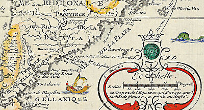
1717 South and North America Poster L'Amerique meridionale et septentrionale
$ 6.6
- Description
- Size Guide
Description
1717 Map of South America and North America.L'Amerique meridionale et septentrionale
Detailed Specifications
This is a reproduction of the original map.
Map Size: 11"x16"
This Map Comes in
16"x23"
too
You can find it and more
Maps of North America
in
Our Store
You can find it and more
Maps of South America
in
Our Store
All Our Posters and Maps Are Made in the USA
In North America, California is shown as an Island with coastal names.
Early Great Lakes configuration.
Mississippi too far to the west.
Several rivers extend to the Rockies from the Mississippi.
Oversized and interesting South America.
New Zealand and the Solomon Islands are shown.
The Canary Islands, the Cabo Verde islands and the Azores are displayed prominently off the coast of Africa.
A crown and feathers are depicted around the border of the dedication cartouche in the upper left corner.
Printed in cartouche in bottom of map :
"L'Amerique Meridionale et Septentrionale Dresée selon les dernieres Relations et suivant les Nouvelles Decouvertes dont les points principaux sont places sur les Observations de Mrs. de l'Accademie Royale des Sciences. Par N. de Fer."
Printed in lower left corner :
"A Paris Cher l'Autheur dan l'Isle du Palais Sur le Quay de l'Orloge a la Sphere Royale Avec priv. du Roy 1717."
Printed in lower right corner in decorative cartouche is a scale with "C. Inselin Scripsit" printed in border of cartouche .
Printed in cartouche in upper left corner :
"Dresée et Dediée A Nosseigneurs les Enfans de France. Par leur tres humble et tres Obeissant Servietuer de Fer. Geogr. De Mgr. Le Dauphin"
This map comes with a white border around the image
---------------------------
-How are the prints shipped?
They are rolled and placed into a rigid tube.
-Is this available in a larger/smaller size.
Yes. For smaller or larger sizes, email us.


